Weather!
9/20/2005 10:01:00 AM

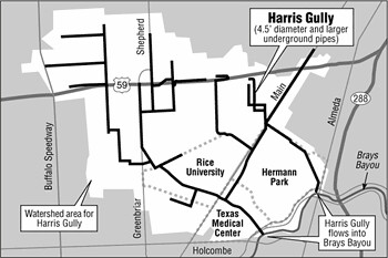
The first picture here is from the Chronicle, depciting the "Harris Gully" - a likely flood area, from what I can determine (we've seen roads here flood during thunderstorms before. I imagine a hurricane will make things quite a bit more interesting.)
This picture below is my superimposition of google maps on the Harris Gully, with a big fat star where our place is. Right on the border.
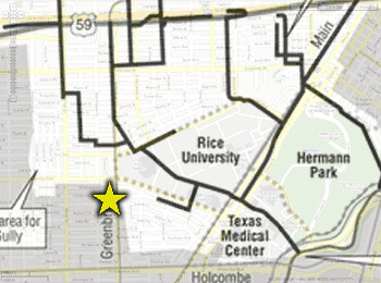
Actually, before this little graphic design exercize, I thought we were on the outside of the gully. But according to this (assuming a pretty accurate map by the Chronicle), we're just INSIDE the gully. Wicked.
And my sister is coming in to visit this weekend. Should be fun.
Check this out to see what's been scaring me this morning. When Tropical Storm Allison hit in 2001, the city was totally flooded. If Rita becomes a Cat 4 or 5 hurricane, we're in for an interesting weekend. I've already decided that it would be prudent for us to pick up water supplies and a lot of canned food today just in case. Along with a battery-operated NOAA radio (and batteries), some tarps (in case windows blow out) and duct tape.
0 Comments:
Post a Comment
<< Home